BEYOND THE STORM — Storm protection through the years
Published 12:37 pm Tuesday, May 1, 2018
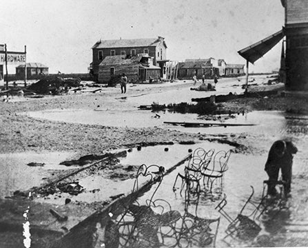
- A photo of Sabine Pass after it was destroyed by a storm on Oct. 12, 1886. (Special to The News)
By Sam Monroe
Special to The News
Hurricanes and tropical storms are a part of life on the Gulf Coast and apparently always have been.
Cabeza de Vaca, a Spanish explorer, the first known European to visit the upper Texas coast, was swept ashore in a storm Nov. 6, 1528. Hernando De Soto, another Spaniard, was beached near present-day Sabine Pass July 25, 1543.
History records other storms after Texas became a state in the Union in 1865, 1871, 1879 and the storm of Oct. 12, 1886, that destroyed Sabine Pass and Johnson Bayou in Louisiana, killing 196 people and 25,000 head of cattle.
In the modern era, the hurricane that struck Galveston in 1900, killing an estimated 6,000 people, remains the most devastating natural disaster in American history. The Aug. 15, 1915, storm that also struck Galveston flooded Port Arthur with a 27-inch rain, leaving 4 feet of water downtown and 7 feet in the Gulf Oil refinery (present-day Valero).
Community leaders realized early that something had to be done to improve drainage and in 1912 the United States Department of Agriculture authorized a drainage survey for all Jefferson County at a cost of $15,000. That same year Port Arthur developed its first drainage system.
The seawall along the Sabine Neches waterway would receive a major improvement in 1931 when it was raised to 9 feet above sea level. A significant rain event occurred on July 26-28, 1943 leading to flooding following 19 1/2 inches of rain. This seemed to lead to an effort to form a drainage district to make further improvements for Mid and South Jefferson County. Drainage District No. 7 was formed in February 1946.
Drainage District No. 7 and Drainage District No. 4 combined in 1961 following a vote of the people. Hurricane Carla in 1961 was the further impetus for drainage improvements leading to the Hurricane Protection System we know today.
The District provides a levee system around Port Arthur, Groves, Nederland and Port Neches containing 107.5 square miles with 16 to 17 feet of protection above sea level. The system designed by the U.S. Corps of Engineers cost $84 million to build with taxpayers in the affected area supporting 30 percent of the cost. The federal government provided the remainder. We all remember the devastation caused by Hurricanes Rita and Ike in the mid-2000s.
This brings us to Tropical Storm Harvey in late August 2017. The stalled system over southeast Texas dropped 65 inches of rain (some areas may have reached 70 inches) over a five-day period and overwhelmed the system. The event set a North America record for the largest amount of rain in recorded history and flooded thousands of homes and businesses throughout South East Texas.
Clearly, our leaders need to begin the process of reevaluating our drainage system to take into account this latest weather phenomenon. This kind of event was probably not taken into consideration in the design of our system.
Knowing our past in this area with tropical weather systems, we must prepare for a more menacing and destructive force of nature than our predecessors experienced. Future generations to come depend on our response and commitment.
Sam Monroe is the retired president of Lamar State College Port Arthur.
This story appeared in Volume 1 of The Port Arthur News Profile, April 8, 2018