7 am STORM UPDATE: Tropical Storm Zeta expected to strengthen
Published 6:56 am Monday, October 26, 2020
|
Getting your Trinity Audio player ready...
|
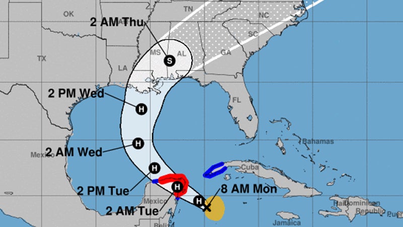
At 8 a.m. Eastern (7 a.m. Monday local time), the center of Tropical Storm Zeta was located over the northwestern Caribbean Sea about 175 miles southeast of Cozumel, Mexico.
Zeta is moving toward the northwest near 9 mph. A northwestward motion with an increase in forward speed is expected over the next day or so, followed by a turn toward the north Tuesday night.
A faster northward to north-northeastward motion is forecast on Wednesday.
On the forecast track, the center of Zeta will move near or over the northern Yucatan Peninsula later Monday afternoon or Monday night, move over the southern Gulf of Mexico on Tuesday and approach the northern Gulf Coast on Wednesday.
Observations from a NOAA Hurricane Hunter aircraft indicate that maximum sustained winds are near 70 mph with higher gusts.
Tropical-storm-force winds extend outward up to 115 miles from the center. Strengthening is forecast to take place, and Zeta is expected to become a
hurricane later Monday morning with additional strengthening before Zeta moves over the Yucatan Peninsula.
Rainfall totals of 4 to 8 inches, with local amounts of 12 inches, are possible through Tuesday along and east-northeast of Zetas track across the Yucatan Peninsula of Mexico, the Cayman Islands, and central to western Cuba.
Zeta is forecast to be at or near hurricane strength when it approaches the northern Gulf Coast on Wednesday, and there is an increasing risk of storm surge, rainfall, and wind impacts from Louisiana to the Florida Panhandle.


