WEDNESDAY 4 pm UPDATE: Hurricane Delta includes SE Texas impacts
Published 4:28 pm Wednesday, October 7, 2020
|
Getting your Trinity Audio player ready...
|
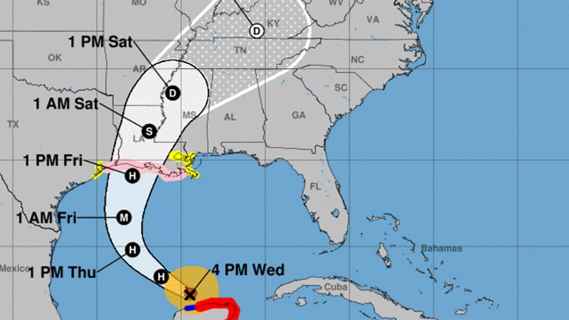
Hurricane Delta has moved into the southern Gulf of Mexico and is slowly strengthening again, according to the National Weather Service, which reported an update at 4 p.m. Wednesday.
Landfall projections for the U.S. show Delta as a category 2 hurricane on Friday in Cameron and/or Vermilion Parish.
Jefferson County is currently under a Hurricane Watch and Storm Surge Watch but not a Flash Flood Watch.
Life threatening storm surge, dangerous hurricane force winds and heavy rain are expected along and east of the track of Delta as it moves inland across Louisiana.
As of 4 p.m. Wednesday, the storm is 685 miles from Port Arthur.
Hurricane Force winds extend 10 to 30 miles from the center of circulation. Tropical Storm Force winds extend 60 to 110 miles from the center of circulation.
Tropical Storm Wind Speed Probabilities for Southeast Texas are 50-80%.
Hurricane Wind Speed Probabilities for Southeast Texas are 5-20%.
Storm Surge in feet above ground level for Southeast Texas is 2-4 feet.
Tides will run one to two feet above normal Wednesday night and Thursday. As Delta approaches the coast on Friday, tides will be higher to the east of the center, and lower to the west of the center.
Rain totals through Monday for Southeast Texas is 1-2 inches.