WEDNESDAY 8am UPDATE: Tropical Depression Beta 70 miles from Port Arthur
Published 8:29 am Wednesday, September 23, 2020
|
Getting your Trinity Audio player ready...
|
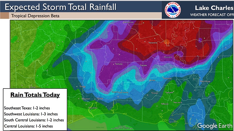
Rain bands from Beta are expected to move through Southeast Texas today, according to the National Weather Service.
East to south winds will gust 20 to 25 mph along and south of the I-10 corridor Wednesday.
Warning Coordination Meteorologist Roger Erickson said an additional one to five inches is possible today, with the highest totals in central Louisiana.
The potential for flash flooding runs into Wednesday night.
Flash flooding is expected in parts of east Texas and central Louisiana.
Storm surge of one to three feet above ground level will continue during high tides across the coast of Texas and Louisiana through Friday.
As of 4 a.m. Wednesday, the storm center was 70 miles from Port Arthur.
Sabine Pass high tides are 12:26 a.m. Thursday and 1:40 a.m. Friday.
Rainbow Bridge high tides are 5:15 a.m. Thursday and 6:09 a.m. Friday.
High tides will run 2-3 feet above normal at Sabine Pass, Calcasieu Pass and Freshwater Canal; and 1-2 feet above normal at Rainbow Bridge, Lake Charles and Amerada Pass.
Southeast Texas can expect two inches of rain Wednesday with locally higher totals possible.
Minor river flooding is forecast along the lower Neches, lower Sabine and lower Calcasieu Rivers.


