WEDNESDAY 4 a.m. UPDATE: Beta 70 miles southwest of Port Arthur; Flash Flood Watch in place
Published 12:01 am Wednesday, September 23, 2020
|
Getting your Trinity Audio player ready...
|
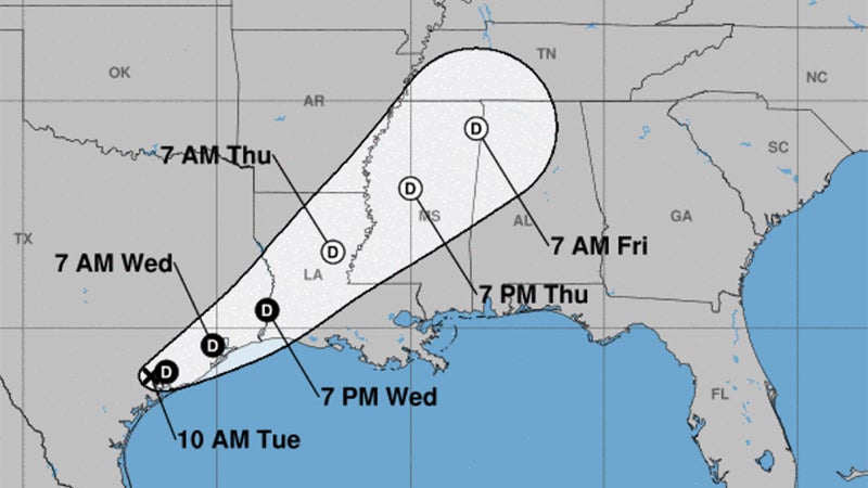
Beta continues its northeastward motion, the National Hurricane Center announced at 4 a.m. Wednesday, bringing heavy rainfall from eastern Texas into the lower Mississippi River Valley.
Flash Flood Watches are in effect across Southeast Texas and Southern Louisiana.
For the upper Texas coast, additional rainfall of 3 to 5 inches with isolated storm totals up to 15 inches is expected through Wednesday afternoon.
Significant urban flooding will continue, as well as minor to isolated moderate river flooding.
At 4 a.m. Wednesday, the center of Post-Tropical Cyclone Beta was located near the Texas coastline approximately 30 miles east-southeast of Houston and 70 miles west-southwest of Port Arthur.
The post-tropical cyclone is moving toward the east-northeast near 9 mph, and this motion is expected to shift toward the northeast during the next 48 hours.
Maximum sustained winds are near 30 mph with higher gusts.
Slow weakening is forecast to take place during the next 48 hours.
The next complete advisory will be issued by the Weather Prediction Center at 10 a.m. Wednesday.
On Tuesday, the National Weather Service predicted Jefferson County could see weather maximum impacts through Thursday of three feet of storm surge, 10 inches of rain, 40 mph gusts and a marginal tornado threat.


