MONDAY 4pm UPDATE: Beta getting more disorganized
Published 4:31 pm Monday, September 21, 2020
|
Getting your Trinity Audio player ready...
|
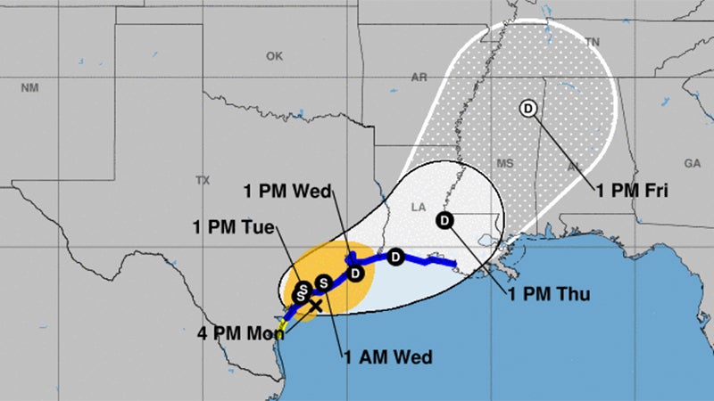
Beta is looking more disorganized on radar and satellite, according to the National Weather Service.
It is near the middle Texas coast and expected to move little over the next 24 hours before drifting up the Texas coast towards Southeast Texas Wednesday and Thursday as a tropical depression.
Warning Coordination Meteorologist Roger Erickson said wind gusts of 20 to 45 mph are expected, with the highest winds along and south of I-10 in Southeast Texas and southern Louisiana.
Rainfall totals will vary greatly across the region.
Some places will see an inch or two.
Other places could see ten inches or more.
It will depend on where the rain bands set up each day this week.
Flash flooding is possible where the heaviest rains fall.
Storm surge of one to three feet above ground level is expected during high tides across the coast of Texas and Louisiana Monday night through Thursday.
There is a small threat for an isolated tornado in Southeast Texas and southern Louisiana Monday night and Tuesday.
As of 4 p.m. Monday, the storm is 175 miles from Port Arthur.
There have been wind gusts of 25 to 45 mph along and south of the I-10 corridor Monday. Tuesday will be similar.
At Sabine Pass, tides will run 2 to 3 feet above normal Monday night into Tuesday, before dropping a little each day through the remainder of the week.
The accumulated rain forecast through Saturday in Southeast Texas is 2 to 5 inches.