MONDAY 10am UPDATE: Tropical Storm Beta path shifts, weather officials say
Published 10:14 am Monday, September 21, 2020
|
Getting your Trinity Audio player ready...
|
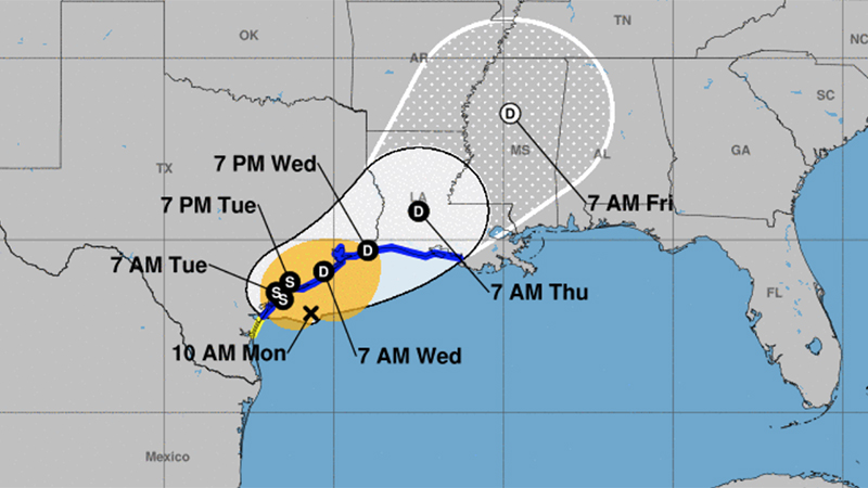
Tropical Storm Beta is weaker and has shifted further west, according to the National Weather Service
Landfall will be Monday night near Matagorda Bay.
Wind gusts of 30 to 40 mph are expected, mainly along and south of I-10 in Southeast Texas and southern Louisiana.
Warning Coordination Meteorologist Roger Erickson said rainfall totals will vary greatly this week across the region.
Some places will see an inch or two. Other places could see ten inches or more, depending on where the rain bands set up each day this week.
Flash flooding is possible where the heaviest rains fall.
Storm surge of one to three feet above ground level is expected during high tides across the coast of Texas and Louisiana Monday through Thursday.
There is a small threat for an isolated tornado in Southeast Texas and southern Louisiana Monday and Tuesday.
As of 10 a.m. Monday, the storm was 170 miles from Port Arthur.
The area of flash flood concern Monday will be the large rain band moving onshore in south central Louisiana.
Wind gusts of 20 to 40 mph are expected today, with the higher gusts along and south of the I-10 corridor.
During high tides through Thursday, they will run 2 to 2.5 feet above normal at Sabine Pass and Calcasieu Pass, and 1 to 2 feet above normal at Amerada Pass.
At Sabine Pass, we are heading into a low tide. High tide will be around 9 p.m. Monday, and continue through 6 a.m. Tuesday.
Locations at risk from flooding: Sabine Pass, Highway 87 between Sabine Pass and Port Arthur, Bridge City and Orange.
The expected total rainfall for Southeast Texas is 1-5 inches.


