Heavy rains, wind to pound Southeast Texas from tropical system
Published 6:30 pm Monday, June 15, 2015
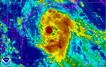
- Satellite image released at 4 p.m. Monday by the National Weather Service Lake Charles office.
A fast-moving tropical disturbance in the Gulf of Mexico is expected to bring heavy rains and wind to Southeast Texas as early as Tuesday morning, prompting Port Arthur Independent School District to cancel Jumpstart and summer school classes.
The District made the announcement Monday afternoon. At the same time, the National Hurricane Center gave the system a 90 percent chance of developing into a tropical storm before it reaches the Texas coast Tuesday morning.
Though landfall could be anywhere between Matagorda and the Texas/Louisiana state line, the storm center is expected to hit somewhere between Corpus Christi and Victoria.
The concern in Southeast Texas is more the winds on the east side of the storm.
Typically, during a tropical storm, rainbands on the east side of a storm are more detrimental than the actual eye of the storm, Donald Jones, meteorologist with the National Weather Service Lake Charles office, said Monday afternoon.
“This is a ragged system, a pretty big storm with bands extending across the Gulf from the Yucatan Peninsula to our area,” Jones said.
Locally, winds in the Port Arthur area are expected to be 20 to 25 mph with gusts as high as 30 to 35 mph. Along the immediate coast of Southeast Texas and Southwest Louisiana, winds could gust as high as 40 to 45 mph. Isolated power outages are expected in the higher winds.
There is also a small tornado threat Monday night into Tuesday, the NWS forecast.
The area is looking at 2 to 3 inches of rainfall Tuesday and Wednesday, Jones said.
“The Port Arthur area is definitely going to feel the impact from it, but is probably not going to be in the heart. Unfortunately, it looks like the Houston areas will get the most out of this,” Jones said.
As of press time Monday, the disturbance had not been upgraded to tropical storm status because of the lack of a defined center.
If the center does become more defined, the system will likely go skip the tropical depression designation and go straight to the named Tropical Storm Bill, the second of the 2015 Atlantic Hurricane Season.
The NWS has also warned a Coastal Flood Warning is in effect. During high tide after midnight Monday night through Tuesday morning, some flooding of roads is expected in Sabine Pass, Cameron, Intracoastal City and Cypremort Point.
In the Houston-Galveston area, which is expected to be more severely impacted, Texas Governor Gregg Abbott has approved the use of state resources staged for rapid deployment as needed to help local officials deal with the storm, The Associated Press reported Monday.
Abbott said because of recent floods from heavy rains, “any additional rainfall will exacerbate already saturated grounds, which could quickly lead to dangerous flash flooding and extended river flooding,” according to the AP.
Galveston County officials have recommended a voluntary evacuation for the low-lying Bolivar Peninsula, where high water and heavy rains are anticipated.
County Judge Mark Henry issued a voluntary evacuation Monday as an alert that emergency responders may not be able to reach people if forecasts are correct that the sliver of land across from Galveston in Southeast Texas could get up to a foot of rain. The storm is expected to hit sometime Tuesday, with an expected landfall farther down the Texas coast.
The Galveston Ferry service could be halted by winds and high tide, the AP reported.
E-mail: sherry.koonce@panews.com
Twitter: skooncePANews
