Harvey becoming a problem for SETX
Published 4:46 pm Monday, August 28, 2017
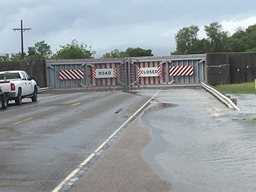
- The floodgates at FM 365 and Rodair Gully were closed on Monday due to flooding in the gully. Rich Macke/The News
Port Arthur and surrounding areas are coping with the problems left by Tropical Storm Harvey.
Sunday’s widespread, heavy rainfall led to officials closing the floodgates at FM 365 and Rodair Gully Monday afternoon.
“Floodwaters were coming in from the gully and back towards the Port Acres area,” Jefferson County Sheriff Deputy Marcus McLellan said of the reason for shutting the floodgates. “Nothing is coming over the levee but water started coming in from the gully. The gates are closed to prevent flooding.”
The floodgates will remains closed until the water goes down.
First responders with the sheriff’s department and Texas Task Force 1 — an urban search and rescue group — made 10 flood rescues in a nine-hour span from 4 a.m. to 1 p.m., mostly in the west area of the county, he said.
In addition, a mandatory evacuation was called for Bevil Oaks and Northwest Forest subdivisions in Jefferson County.
Acadian Ambulance experienced some minor delays due to high water with moderate street flooding and are working with their partners at the Port Arthur Fire Department to get patients the medical care they need, according to an official with Acadian.
“To respond to the challenges caused by Tropical Storm Harvey, we have added an extra crew, converted our schedules to allow us to quickly increase staffing and have a number of employees on standby and ready to respond,” Denise Richter, Texas marketing and PR manager for Acadian, said.
Risa Carpenter, public information officer for the city of Port Arthur, said all public safety personnel were out diligently doing their jobs and asked for citizens to stay off the roads as more rain is in the forecast.
“Be aware of your surroundings,” Carpenter said. “Driving through flooded areas will cause a wake that will push water into people’s homes so it’s best not to get out and drive.”
Due to sporadic rain and flooding, the city is urging citizens to turn around, don’t drown. They can also check drivetexas.org for current road conditions.
The area has seen about 18 inches of rain since the outer rain bands hit on Saturday.
But there is rain to come.
“We’re looking at the potential for a whole lot more rain, 10 to another 20 inches in the worse case scenario,” Donald Jones, meteorologist with the National Weather Service-Lake Charles, said.
The county is under a tropical storm warning as Harvey is predicted to gradually drift off to the Gulf of Mexico then make another landfall west of Jefferson County before working its way north on Wednesday and Thursday.
The storm will likely strengthen very slightly bringing tropical force winds.
“We want to emphasize the winds are not the big issue. Heavy rain falling is the problem,” he said. “We are not expecting any major damage from the winds.”
There will be minor storm surge along the coast of one-to-three feet and timed with the high tide Tuesday morning.