Levee work underway as officials keep eye on the Gulf
Published 7:20 pm Tuesday, August 22, 2017
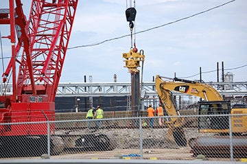
- Crews work to stabilize a portion of the levee wall along Taylor Bayou on Tuesday. David Ball/The News
A damaged portion of a levee is being fortified with super sized sandbags and steel as officials anticipate heavy rainfall from a tropical disturbance.
Phil Kelley, general manager for Jefferson County Drainage District 7, said there are 1,700 of the super sized sandbags in place and approximately 1,200 on site for emergency use.
“Ever since we mobilized, our contract has been placing sand bags on the water side of the failed wall section; first to stabilize the wall to keep it from moving more. As that’s completed, the contractor is beginning to drive steel sheet piles as we speak,” Phil Kelley said.
The remnants of Tropical Storm Harvey are expected to move into the Bay of Campeche by Wednesday and could redevelop into a tropical depression. There is a chance the storm could strengthen into a category 1 hurricane by landfall on Friday on the central Texas coast, according to meteorologists with the National Weather Service-Lake Charles.
Kelley said DD7 is prepared for the possibility of heavy rainfall and storm surge.
“All of the pumping facilities will be manned during the rain,” he said. “We’ll do what we normally do, remove storm water. That part hasn’t been compromised at all during this.”
Jefferson County Emergency Management Coordinator Greg Fountain said the levee project is being monitored all the way to the state level and it should be fortified to withstand what Harvey could potentially bring.
Fountain joined Kelley, county officials, Port Arthur City Manager Brian McDougal, Port Arthur’s emergency management coordinator and deputy emergency coordinator as well as representatives of Mason Construction and Bob Shaw Consulting Engineers on site as work was being done.
As for citizens facing heavy rain, possible street flooding and wind, Fountain asks they be ready.
“We need citizens tot be responsible for their selves and families and have a family plan in place,” Fountain said. “Be prepared for some possible localized flooding that has nothing to do with the wall. There may be rain and wind and power outages.”
Roger Erickson, warning coordination meteorologist with the NWS-Lake Charles, said there are a lot of unknowns about the storm.
“It hasn’t developed yet,” Erickson said Tuesday afternoon. “Right now it’s just a cluster of storms. We think it will become a tropical depression tomorrow and then there’s the potential for a category 1 hurricane before it makes landfall on Friday.”
Storm surge is a big issue along the coast and Harvey brings the potential for a storm surge in Jefferson County.
“In terms of value, Sabine Pass has the potential to see water five–feet above ground level but it’s too early to say,” he said.
Because the storm is slow moving it has the potential to dump anywhere from seven inches of rain to 14 inches of rain over the weekend beginning on Friday.