Weather Service outlines early week severe storm threat for SETX
Published 11:59 am Sunday, December 11, 2022

|
Getting your Trinity Audio player ready...
|
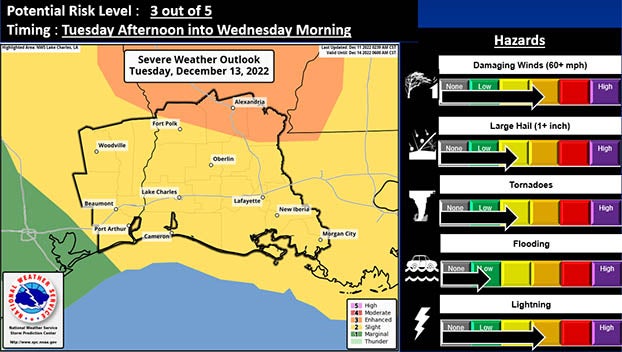
The National Weather Service expects severe weather to impact Port Arthur, Mid County and the rest of Southeast Texas Tuesday afternoon into Wednesday morning.
There is an enhanced to slight risk of severe thunderstorms expected as a strong storm system and stronger cold front pushes through the southern plains.
All modes of severe weather are possible: damaging wind gusts, large hail and tornadoes.
(According to the National Weather Service)
There is also a threat for heavy rain and flash flooding.
The slight risk (level 2 out of 5 or between 15 and 29 percent chance) exists for
most of the region.
The enhanced risk (level 3 out of 5 or greater than 30 percent chance) exists in central and north Louisiana, including Vernon, Rapides and Avoyelles parishes.
Storms are expected to move east to west across the area with showers and thunderstorms, starting Tuesday morning.
The risk of severe weather begins in the afternoon hours.