TUESDAY MORNING UPDATE: Weather Service outlines where, when severe storms may strike today
Published 6:24 am Tuesday, November 29, 2022

|
Getting your Trinity Audio player ready...
|
As of 6:15 a.m. Tuesday, the National Weather Service updated its Hazardous Weather Message for Southeast Texas with the potential for severe storm and excessive rainfall.
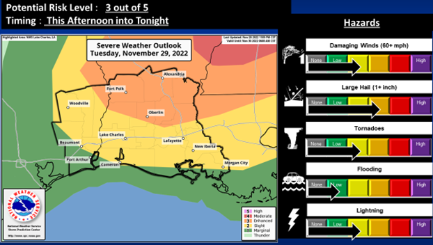
An enhanced risk potential (level 3 out of 5) to slight risk potential (level 2 out of 5) for storms that develop to become severe is expected.
This potential includes all modes of severe weather, including damaging wind gusts, large hail and a few tornadoes, along with occasional cloud to ground lightning.
(Courtesy of the National Weather Service)
In addition, there is a slight risk potential (level 2 out of 4) to marginal risk potential (level 1 out of 4) for excessive rainfall that may lead to flooding.
The stronger storms will produce intense rainfall rates of 1 to 2 inches per hour that may cause flooding of urban poor drainage areas and roadways, as well as locations where grounds are still wet from recent rainfall.
The severe – enhanced risk potential (level 3 out of 5) for the area is roughly northeast of a Newton to the Opelousas line.
The slight risk potential (level 2 out of 5) is for the remainder of the area.
The excessive rainfall – slight risk potential (level 2 out of 4) for the eastern portions of Avoyelles and St. Landry Parishes.
The marginal risk potential (level 1 out of 4) for the remainder of the area roughly east of a Jasper to Beaumont line.
First there is a forecast of isolated to scattered thunderstorms that have the potential to go severe from noon to 8 pm. Tuesday.
Then bands of thunderstorms possibly forming into a squall line is from 8 p.m. Tuesday to approximately 4 a.m. Wednesday.