National Weather Service warns of excessive rainfall, flash flooding potential
Published 7:22 am Thursday, August 25, 2022
|
Getting your Trinity Audio player ready...
|
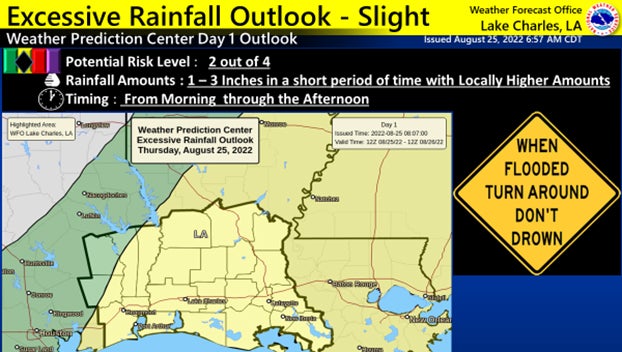
Forecasters have a continued hazardous weather message for motorists in and around Port Arthur and Southeast Texas on Thursday: there is a continued risk for excessive rainfall and flooding.

(Courtesy of the National Weather Service)
Thunderstorms are expected with high rainfall rates of 1 to 3 inches or more in an hour, with rainfall totals exceeding 5 inches in some spots where thunderstorms repeat themselves.
This may lead to flooding of poor drainage urban areas.
Also, if these rainfall amounts fall over areas where grounds have become saturated, then flooding of creeks, bayous, drainage ditches and other low lying areas will be possible.
The Thursday Flood Watch extends along and north of a Port Arthur to Opelousas line.
A slight risk potential (level 2 out of 4) for excessive rainfall leading to flash flooding exists for the entire forecast area.
Concerns starting this morning with the potential for flooding lasting into Thursday afternoon.
(Courtesy of the National Weather Service)