WEATHER SERVICE: Hurricane force wind gusts expected in extended region
Published 3:06 pm Tuesday, March 29, 2022
|
Getting your Trinity Audio player ready...
|
Windy conditions will be increasing Tuesday night into Wednesday due to a tightening pressure gradient.
Expect some tree limbs to blow down and isolated to scattered power outages, especially along and south of the I-10 corridor of Louisiana, according to the National Weather Service.
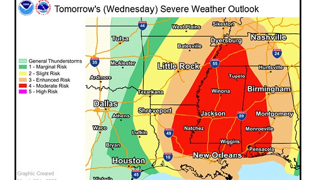
(Courtesy of the National Weather Service)
Warning Coordination Meteorologist Roger Erickson said a line of strong to severe thunderstorms will move across the region on Wednesday.
“Some places in central and south central Louisiana could see hurricane force (over 74 mph) wind gusts,” Erickson said. “A strong tornado (EF-2 or more) is possible in parts of central and south central Louisiana.”
For marine interests, expect gale criteria to be met for at least the gusts, over 35 knots Tuesday night into Wednesday.
In addition, due to the strong onshore flow, expect to see some minor coastal flooding during high tide overnight into Wednesday morning.