Weather Service talks Monday/Tuesday forecast for SETX and updates freeze concern
Published 7:29 am Monday, January 3, 2022

|
Getting your Trinity Audio player ready...
|
Port Arthur and Mid County residents can expect another night of near freezing temperatures Monday, but gradual warming is expected.
National Weather Service Meteorologist Alex Donato told Port Arthur Newsmedia Monday morning that today’s high should reach near 50.
“By Wednesday, we will probably be in the low 70s for high temperatures,” he said. “Tuesday night will be another cold one; maybe not quite as cold as what Sunday night was.”
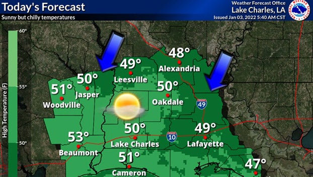
(Courtesy of The National Weather Service/Lake Charles, La. office)
According to Donato, Southeast Texas can expect a pattern of more frequent cold fronts coming through compared to what December was like.
“We are expecting another cold front to make its way through the area, thereabouts in the Thursday timeframe,” he said. “We’re going to see another significant cool down associated with it.”
Donato stopped short of saying South Jefferson County should expect freeze conditions anytime this week.
“This time of year we do generally see the large fluctuations in temperature,” he said.
“We are technically in a La Niña, which tells us we are going to be trending above average (warmer). That is the general expectation for winter this year.”
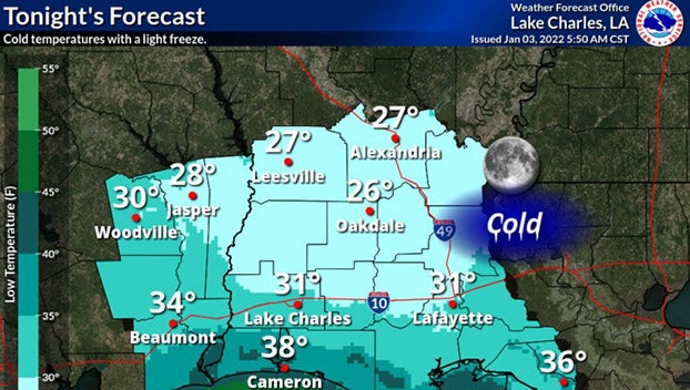
(Courtesy of The National Weather Service/Lake Charles, La. office)
On Monday morning, the Weather Service said to expect mostly sunny conditions Monday with winds not as strong and gusty as the past couple of days.
A light freeze can be expected mainly along and north of the I-10 corridor.
High pressure is expected to move off to the east on Tuesday, and this will allow winds to gradually come from the southeast and help bring milder temperatures with highs in the upper 50s to low 60s.