STORM WATCH — Hurricane Ida strengthened to a category 2 hurricane
Published 12:01 am Saturday, August 28, 2021
|
Getting your Trinity Audio player ready...
|
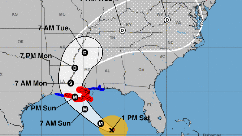
EDITOR”S NOTE: 1 p.m. Eastern/Noon Saturday update: Ida has strengthened to a category 2 hurricane with 100 mph winds.
The forecast track remains the same. Landfall Sunday evening near Morgan City, LA as a category 4 hurricane.
Original story:
Weather officials are not expecting Ida to make landfall in southeast Texas or southwest Louisiana!
Nothing significantly has changed since Friday night with Hurricane Ida.
The forecast track continues to the northwest, with a landfall projection in south central Louisiana near Morgan City, LA.
Timing of the landfall still looks like Sunday night.
Ida is still expected to rapidly intensify today and tonight, becoming a category 3 or 4 hurricane before landfall.
The eyewall of a hurricane is where the strongest winds will be found. People in St. Mary, St. Martin and Iberia Parishes should be prepared for wind gusts in excess of 100 mph.
In addition, the storm surge will increase after the storm makes landfall, so by Monday morning the water will still be rising at the coast, and working inland through the various rivers and bayous.
Water levels of 6 to 9 feet are possible in coastal sections of Iberia and St. Mary Parishes, including the Cypremort Point and Burns Point areas.
Elsewhere across south central Louisiana, you can expect hurricane force wind gusts of over 75 mph. This includes Vermilion and Lafayette Parishes. Depending on where Ida moves after landfall, this could extend into St. Landry Parish as well.
In addition to the wind and surge, we are also expecting a significant amount of rainfall. Six to twelve inches of rain is possible across St. Mary, Iberia, St. Martin, and St. Landry Parishes.