National Weather Service outlines expected SETX impacts from hurricane
Published 12:03 am Friday, August 27, 2021
|
Getting your Trinity Audio player ready...
|
A major hurricane is expected to hit the Louisiana coast late Sunday or early Monday.
The highest risk area is between Intracoastal City and Grand Isle, according to the National Weather Service.
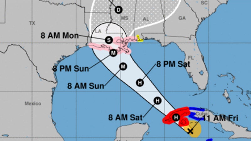
The National Weather Service released this hurricane track at 11 a.m. Eastern/10 a.m. Central on Friday.
Life threatening storm surge, damaging hurricane force winds, heavy rains and tornadoes are all risks with this system. Typically the worst parts of the hurricane are along and to the east of where it makes landfall.
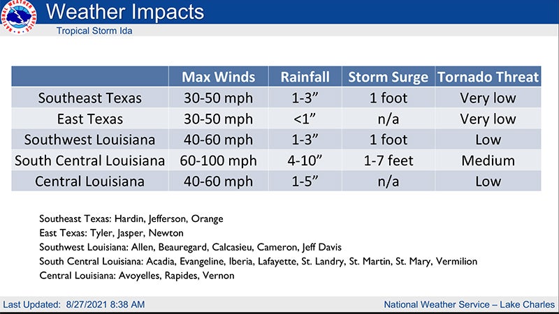
Warning Coordination Meteorologist Roger Erickson said Southeast Texas is expected to see 30 to 50 mph wind gusts Sunday night into Monday.
READ HERE: 4 pm FRI STORM WATCH – Weather Service updates Southeast Texas expected impacts.
Rainfall will be one to three inches. Storm surge will be a foot or less. There is a minimal tornado threat.
Southwest Louisiana is expected to see 40 to 60 mph wind gusts Sunday night into Monday. Rainfall will be one to three inches. Storm surge will be one foot. There is a minimal tornado threat.
South central Louisiana could see wind gusts of 60 to 100 mph Sunday night into Monday. Rainfall will be four to ten inches. Storm surge will be one to seven feet. There is a moderate tornado threat.
Central Louisiana could see wind gusts of 40 to 60 mpg Sunday night into Monday. Rainfall will be one to five inches. There is a low tornado threat.