5:30 a.m. UPDATE: National Weather Service breaks down Port Arthur, Mid County forecast
Published 5:54 am Wednesday, May 19, 2021
|
Getting your Trinity Audio player ready...
|
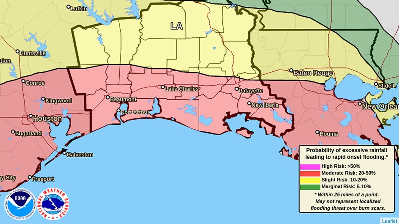
Port Arthur and Mid County may see another 4 inches of rain in the next 24 hours, according to the National Weather Service.
Meteorologist Alex Donato updated Port Arthur Newsmedia at 5:30 a.m. Wednesday, saying there are quite a few moderate rain showers expected throughout the area, adding it is possible an additional squall line will form to the south.
A torrential downpour or rain accumulation like the area experienced Monday is not expected Wednesday.
“The area does remain in a marginal risk,” Donato cautioned. “Some additional rainfall is expected through the day (Wednesday) into tonight, with rainfall accumulations in the three to four inches.”
Wednesday evening is going to be the highest likelihood of rain in terms of accumulation — “we’re looking at close to two inches,” Donato said.
Wind gusts
The airport in Lake Charles, Louisiana, recorded a wind gust Wednesday before daybreak of 69 mph.
That level of strong wind isn’t likely to impact Port Arthur and Mid County residents; however, the region is expected to endure moderate winds throughout the day that increase in intensity Wednesday evening.
Donato said sustained winds should each 15 to 20 mph, with possible gusts into the 20 or 25 mph range.
Read here for local community reaction to region’s severe weather.