FRIDAY 10 am UPDATE: Port Arthur, Mid-County to see stronger winds starting at noon
Published 10:28 am Friday, October 9, 2020
|
Getting your Trinity Audio player ready...
|
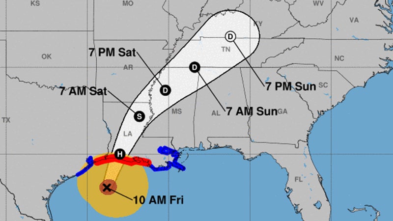
Projections as of 10 a.m. Friday show Delta as a category 2 hurricane making landfall Friday evening in eastern Cameron Parish.
As of 10 a.m., the storm is within 130 miles of Port Arthur.
Delta’s northern side is now coming onto the coast of Texas and Louisiana.
Hurricane Force winds extend 25 to 35 miles from the center of circulation. Tropical Storm Force winds extend 80 to 140 miles from the center of circulation.
As of Friday morning, a large band of light to moderate rain is moving across Southeast Texas and southern Louisiana.
Port Arthur and Mid-County could start seeing 40 mph winds with higher gusts by noon Friday.
Local storm is expected to be minimal and no more than two feet.
Rain totals through Monday for Southeast Texas are expected to be 2-6 inches.
For today through Saturday, Delta is expected to produce 5 to 10 inches of rain, with isolated maximum totals of 15 inches, from southwest into central Louisiana.
These rainfall amounts will lead to significant flash, urban, small stream flooding, along with minor to major river flooding.
For extreme east Texas into northern Louisiana, southern Arkansas and western Mississippi, Delta is expected to produce 3 to 6 inches of rain, with isolated maximum totals of 10 inches.
These rainfall amounts will lead to flash, urban, small stream, and isolated minor river flooding.