MONDAY 10 pm UPDATE: Laura to reach hurricane strength within 18 hours
Published 10:34 pm Monday, August 24, 2020
|
Getting your Trinity Audio player ready...
|
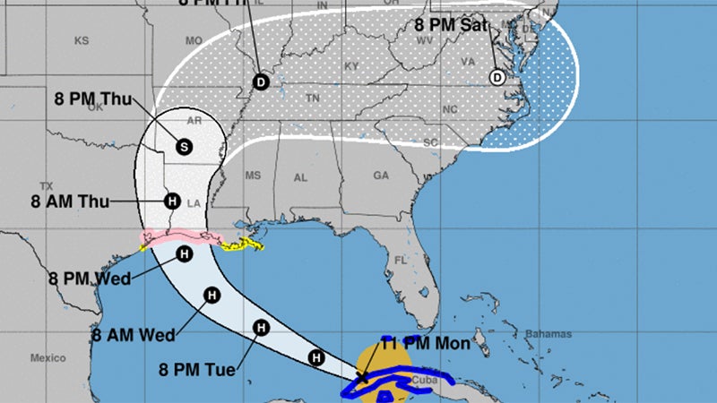
Laura will strengthen to a hurricane in the next 6 to 18 hours before making landfall in Southeast Texas to south central Louisiana late Wednesday/early Thursday as a category 2 or 3.
Jefferson County is under a Hurricane Watch, which would likely become a warning Tuesday.
Tropical Storm force winds could start Wednesday morning near the south central Louisiana coast, and Wednesday afternoon and evening for southeast Texas and southwest Louisiana.
There is a potential for widespread damage near the coast from storm surge. Damage from the surge could extend 20 or 30 miles inland.
The average error for hurricane forecasts is 70 to100 miles off for two to three days in advance of landfall, so do not focus on the individual forecast points, but use the error cone instead.
If you are in the error cone you could see the worst part of the hurricane winds.
Everyone should be preparing for a category three hurricane due to the average forecast errors when it comes to wind speeds (+/-15-20 mph for 2-3 days in advance).
This is the forecast weather impacts for the region:
Winds: Hurricane force winds will be possible across the region starting late Wednesday and continuing early Thursday. Hurricane force winds could last 6 to 10 hours. Tropical Storm force winds could last 16 to 24 hours.
Storm Surge: At the coast, water could be over 10 feet above ground level. Depending on where Laura makes landfall, storm surge can back up rivers and bayous and flood over 30 miles inland.
Rainfall: Depending on where the rain bands form, 5 to 10 inches with locally 15 inches will be possible starting Wednesday into Thursday.
Tornadoes: Tornadoes will be possible in the eyewall as the hurricane approaches the coast, as well as outer rain bands starting Wednesday into Thursday.