Tropical Depression shifts west, local officials react
Published 4:56 pm Friday, August 21, 2020
|
Getting your Trinity Audio player ready...
|
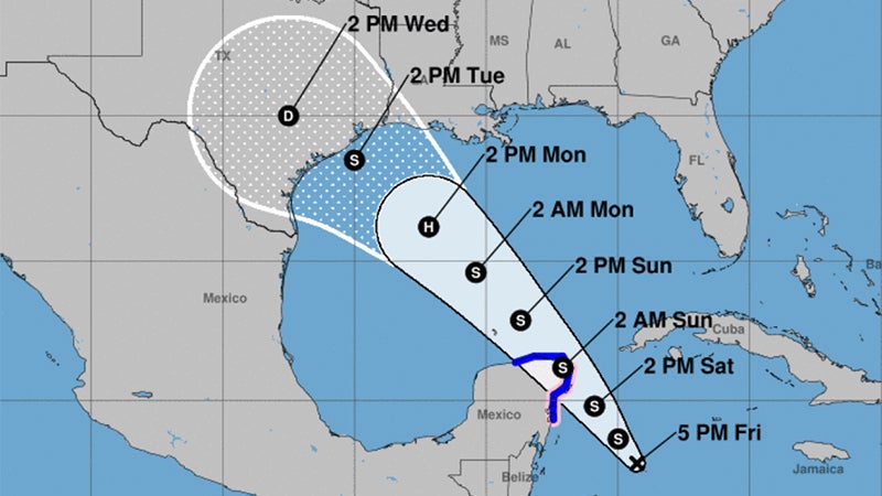
Thursday afternoon’s forecast shifted Tropical Depression 14 further west.
There is still high uncertainty regarding the track and intensity forecast for both tropical systems, according to the National Weather Service.
Tropical Depression 14 is disorganized but should become a tropical storm Friday night or Saturday.
Warning Coordination Meteorologist Roger Erickson said it is forecast to be in the southern Gulf of Mexico on Sunday, and threaten Texas on Tuesday.
Tropical Storm Laura is forecast to move into the southeastern Gulf of Mexico Monday into Tuesday, and threaten Louisiana, possibly as a hurricane by Wednesday.
It is too early to know specific weather impacts to the region.
Damaging winds, heavy rain and higher tides are all possible.
Tides will likely run a foot above normal on Sunday, and could increase next week.
Local officials react
Not one but two tropical systems are inching forward toward the warm Gulf of Mexico waters, one of which seems targeted for Southeast Texas and Southwest Louisiana.
Local and county leaders are maintaining contact with weather authorities on what action to take, if any, as conditions change.
Jefferson County Judge Jeff Branick said for several days now, the county’s office of emergency management has been on daily calls with weather officials at 10 a.m. and 4 p.m.
County leaders are also getting information from spaghettimodels.com and other weather-related sites.
“We sometimes have the opportunity to take advantage of the work of private meteorological firms that work with industry,” Branick said.
The storm’s path will take it across the Yucatan Peninsula Sunday night or Monday.
“We are watching very closely and have already been coordinating with the Texas Division of Emergency Management on staging areas if we need them,” he said, adding no one can really forecast the intensity of the storm until it passes over the Yucatan Peninsula and into the open waters of the Gulf.
Branick offered some advice for citizens; go to ready.gov, where you will find a lot of information for preparation.
Port Arthur Fire Department Deputy Chief Louie Havens, who is also deputy emergency coordinator, said city leaders are keeping abreast of the storm with the twice-daily weather briefings and the state is also making calls daily.
Havens said they are monitoring weather media outlets and conducting own daily city briefings to keep department heads updated on current conditions.
The message to citizens is to maintain awareness of what the weather media is putting out, the National Weather Service especially, and take precautions in advance.
“Make sure all of your medicine is up to date, make sure you have some non-perishable food around the house,” Havens said. “Nobody is talking about evacuation, but have yourself a plan if something like that arises. Have a destination picked out and plan on how to get there.
“Touch base with friends and family if that is your plan. Think about what to do with your pets. If you are a caregiver, what kind of preparedness do you need to make for your loved ones?”
Havens also advises for residents to be registered with The Southeast Texas Alerting Network, or THE STAN.
You can do so at the city’s website, portarthurtx.gov, then departments and emergency management.
This is the city’s alerting network, which will send pertinent messages when needed.