Hurricane expected to hit Lake Charles area Saturday evening
Published 11:05 am Wednesday, July 10, 2019
- The combination of a dangerous storm surge and the tide will cause normally dry areas near the coast to be flooded by rising waters moving inland from the shoreline.
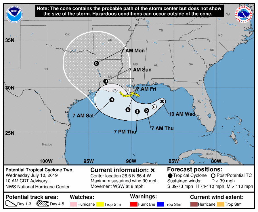
The storm activity in the Gulf of Mexico is expected to make landfall Saturday evening as a hurricane somewhere near Lake Charles, according to the National Hurricane Center.
A Storm Surge Watch has been issued from the Mouth of the Pearl River to Morgan City in Louisiana.
A Tropical Storm Watch has been issued from the Mouth of the Mississippi River to Morgan City in Louisiana.
A Tropical Storm Watch means that tropical storm conditions are possible within the watch area, generally within 48 hours. Interests elsewhere along the U.S. Gulf Coast from the Upper Texas Coast to the Florida Panhandle should monitor the progress of this system, according to the National Hurricane Center.
More watches and warnings will be issued as the storm develops.
The system is moving toward the west-southwest near 8 mph. A motion toward the west-southwest or southwest is expected through Thursday morning, followed by a turn toward the west late Thursday and a turn toward the west-northwest on Friday.
By early Saturday, a northwest motion is expected.
The storm system is expected to approach the central U.S. Gulf Coast this weekend with maximum sustained winds near 30 mph with higher gusts.
Strengthening is forecast during the next 72 hours, and the disturbance is forecast to become a tropical depression Thursday morning, a tropical storm Thursday night, and a hurricane on Friday.
Shower and thunderstorm is gradually been increasing in coverage and organization, and the low is likely to become a tropical depression or a tropical storm in the next day or so.
The combination of a dangerous storm surge and the tide will cause normally dry areas near the coast to be flooded by rising waters moving inland from the shoreline.
Surge-related flooding depends on the relative timing of the surge and the tidal cycle, and can vary greatly over short distances.
The system is expected to produce total rain accumulations of 6 to 12 inches near and inland of the central Gulf Coast through early next week, with isolated maximum rainfall amounts of 18 inches. Tropical storm conditions are possible within the watch area by late Thursday or early Friday.